
Eye to Eye With the Gulf Coast’s Stormy Future
By Safina Center Fellow Marlowe Starling
Hurricane Milton was the Gulf’s strongest late-season storm. Climate change ensures this is a new normal.
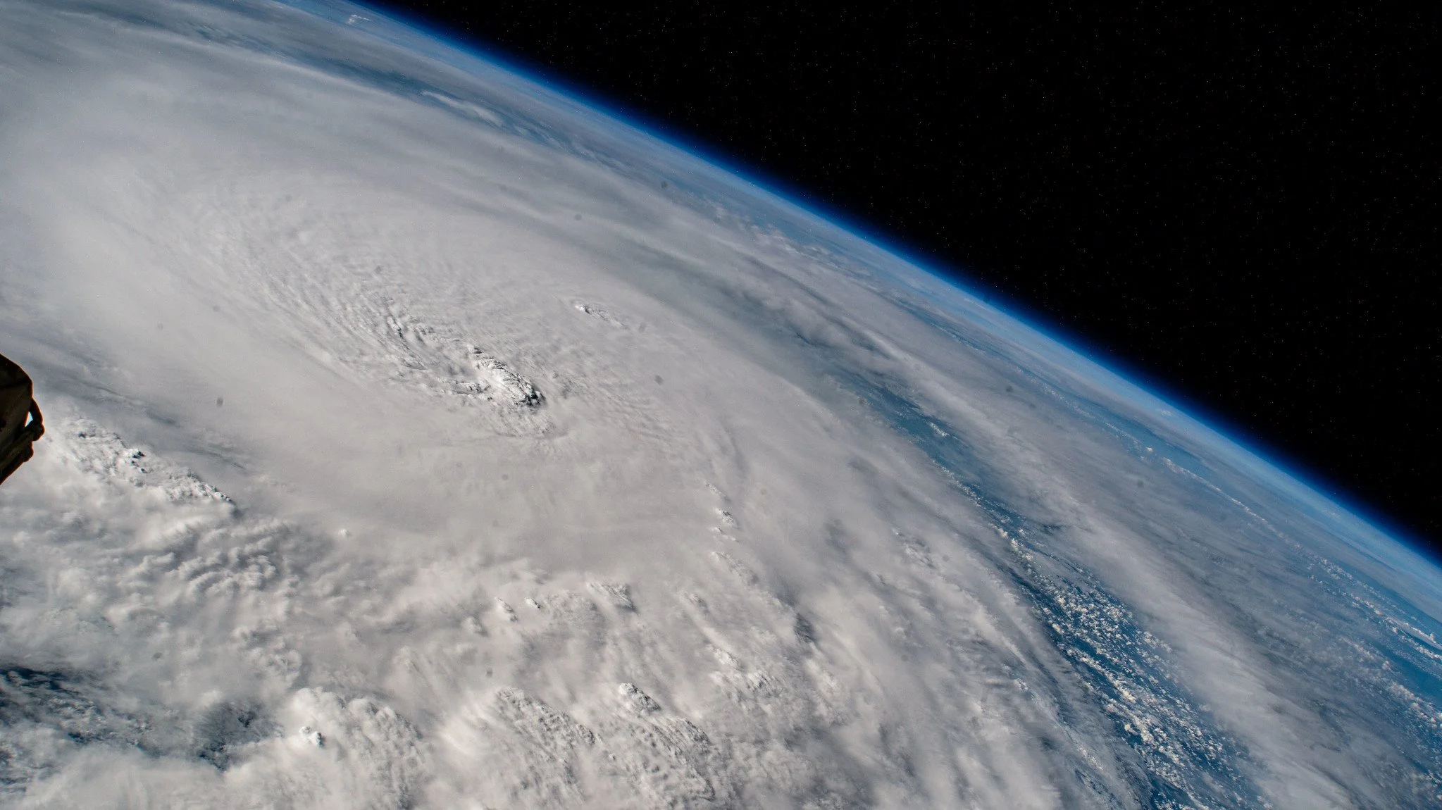
Image of Hurricane Milton in the Gulf of Mexico, taken from the International Space Station. At the time, it was a category 4 storm. ©NASA Johnson Space Center
I grew up listening to hurricane stories, but the most captivating were those about Hurricane Andrew. The Category 5 storm hit Miami head-on in 1992, when my parents were still 14 months away from meeting each other. Hurricane-proof windows didn’t exist. Homeowners used masking tape on their windows instead of shutters. Evacuation orders were not in place. And Miami had never seen a stronger storm in modern history.
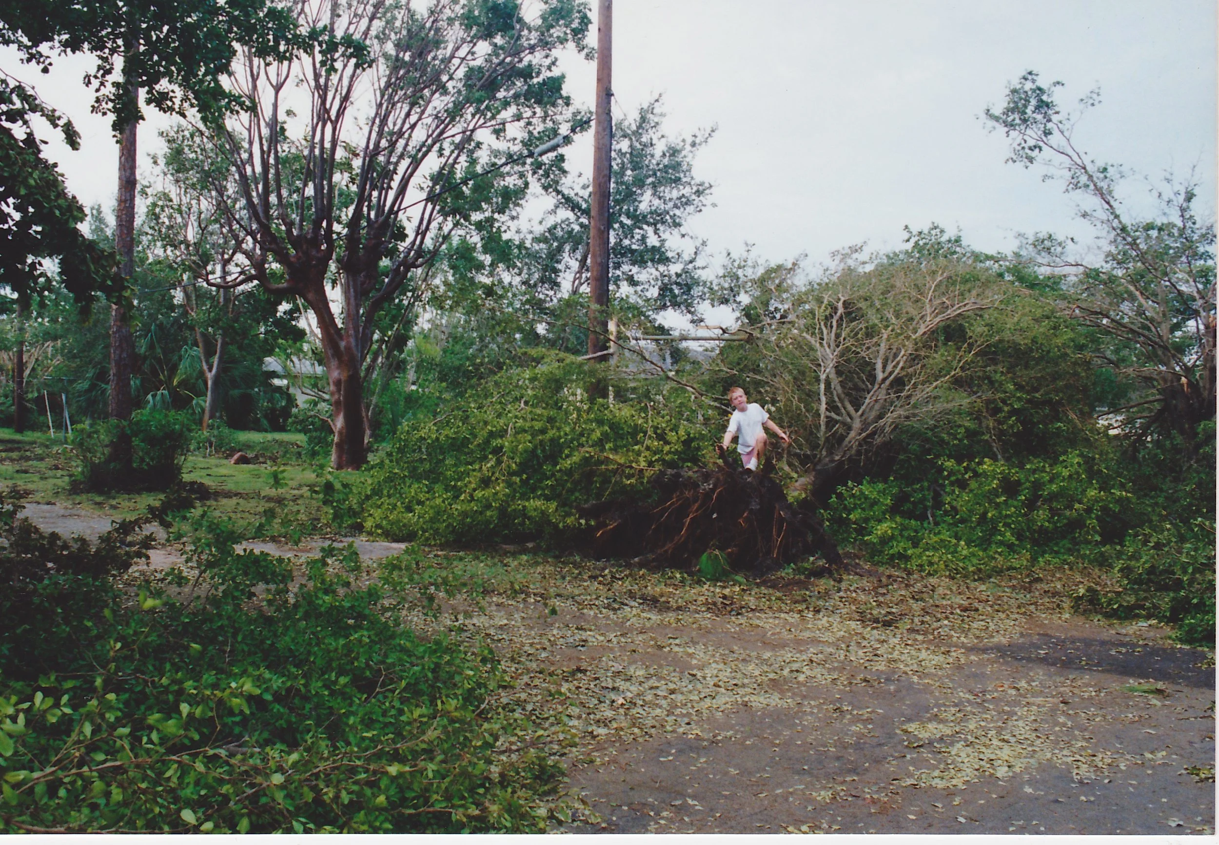
Fallen and uprooted trees near the University of Miami on Monday, August 24, 1992 after Hurricane Andrew blew over Miami. The Hurricane Center's radar at the University of Miami was taken out by a 164mph gust of wind. ©Robin Godwin
In a four-bedroom house that carried an eight-person family, my dad pushed all his weight against a door to keep it from blowing in while the mattress levitated inside from the wind. His siblings—one of whom was pregnant with her second child—hunkered in the bathroom. Most memorable was the sound overhead, like a freight train.
Half an hour away, all that remained of some two-story townhomes were the toilets.
And about 6 miles northeast, the destruction left my 22-year-old mother speechless. She was at a nightclub the night before; now, her neighborhood was unrecognizable. Hurricane Andrew flattened Miami, and parts of the city were never the same again.
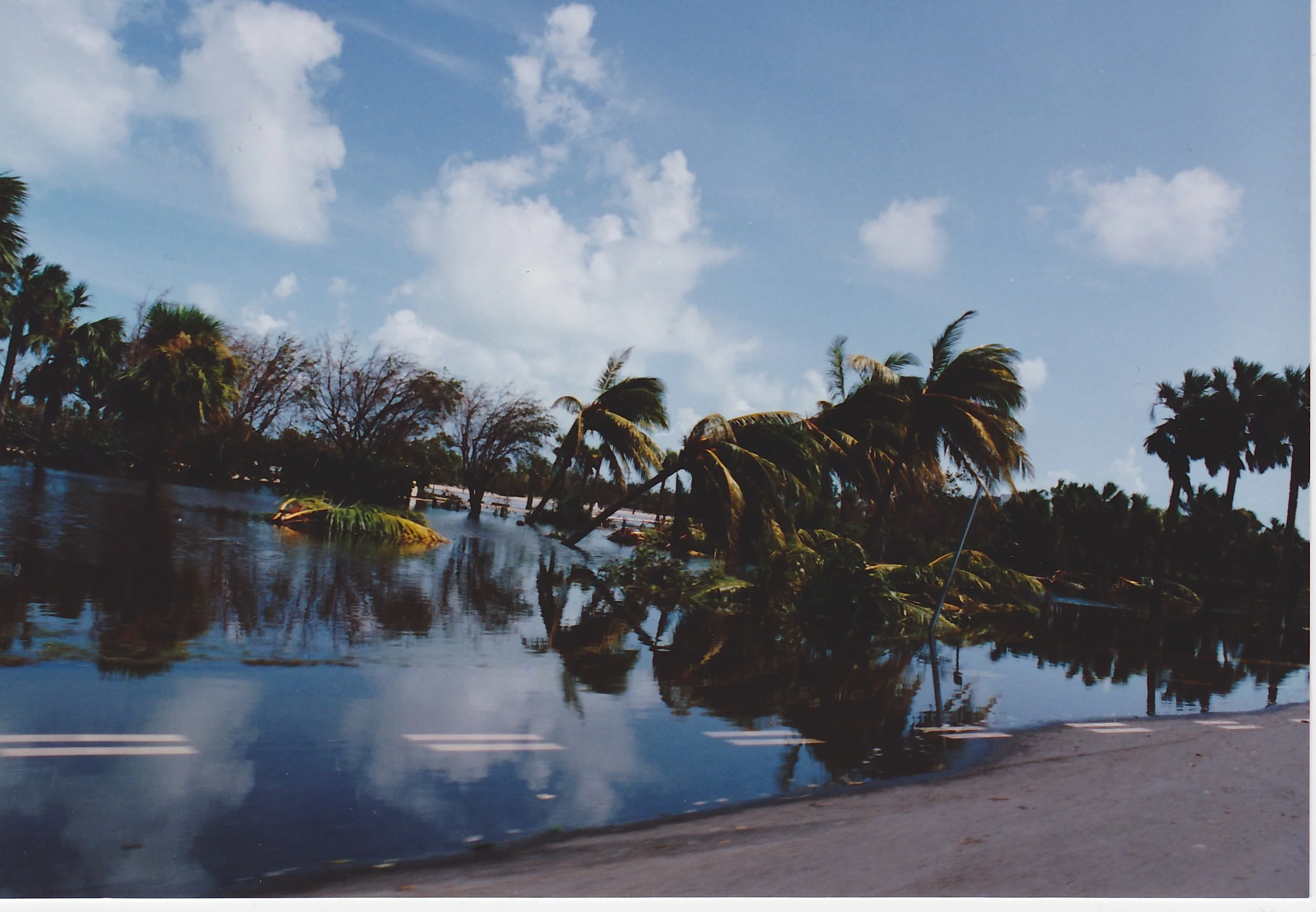
Flooding and fallen palm trees after Hurricane Andrew on Key Biscayne. ©Robin Godwin
So, when I watched NBC6 meteorologist John Morales choke back tears while delivering information about Hurricane Milton’s near-record intensification in the Gulf of Mexico, it sent chills over my body. “It has dropped… 50 millibars,” Morales said over the forecast. “…in 10 hours.” Visibly blinking back tears, and after swallowing a knot in his throat, he apologized. “This is just horrific.”
The then-Category 5 storm was sitting over the Gulf as it approached the Yucatan peninsula, where the ocean temperatures are record hot, he explained. “You know what’s driving that, I don’t need to tell you: global warming, climate change, leading to this and becoming an increasing threat.”
What I saw in Morales’ face and heard in his voice was what I had been feeling all week: the weight of understanding that storms like this are officially our new normal.
In an as-told-to piece for Mother Jones, Morales perfectly described the complicated emotions I was grappling with. “It was a mixture of angst about increasing extremes, frustration for lack of action on climate knowing where we’re going, and just empathy for the victims or future victims in Milton’s path,” he wrote. “I was just feeling anxiety about what’s going to happen to them and how nervous they must be.”
Watching a natural disaster barrel toward your home state while you’re living far away is a unique experience. Soon after I moved to New York City for graduate school, sometime in late September, my classmates asked if I was doing okay and if my family was safe. “What, because of Hurricane Ian? Ha!” I quipped. “Everyone down there is probably prepping for hurricane parties. This is nothing.” Then, Ian intensified to a Category 4. The next day, I walked in a bit more somber. “I’ll admit… now I’m worried.” Thankfully, Hurricane Ian didn’t do a lot of damage to my parents’ home—despite being just half a mile from Biscayne Bay and located in a Flood Zone AE, one of the highest-risk areas—but it did flood more vulnerable, less resourced, and poorer areas of the city to unimaginable levels. Our coastlines are not built to withstand the type of rainfall and flooding scientists predict as record-high ocean temperatures continue to fuel larger, more rapidly intensifying storms in the future.

GeoColor image of Hurricane Milton on the night of landfall. Photo provided by CIRA/NOAA.
This time, when Tropical Depression Fourteen radically transformed into Hurricane Milton, I felt nauseous. Each morning, I woke up, checked hurricane updates for 15 minutes, then texted a long list of friends and family about their evacuation plans and preparations. One friend, a climate and environmental journalist at the Tampa Bay Times, decided to stay with his colleagues in Pinellas County—where storm surge was projected to reach 12 to 15 feet (The Times produced round-the-clock live updates and reported crucial information to residents on the ground, a heroic feat of climate journalism that was provided sans-paywall to all readers.) It was strange to feel comforted knowing my parents and other immediate family were safe in Miami, outside of the storm’s path, but the impending storm didn’t feel any less stressful.
As I checked the live updates each morning, anticipating the storm’s landfall, I couldn’t help but cry. Some people lost their homes from Hurricane Helene just two weeks earlier. Others didn’t have the resources to take their children and pets to a hotel. And hundreds more struggled to fill their cars with enough gasoline to escape flood zones. Those tears were fueled by a deep empathy for my home state—the people and environments alike. Thinking about the destruction and cleanup along Florida’s Gulf Coast broke my heart.
Then came comedic relief amid the doom scrolling: a social media personality sharing live updates of turtle and shark tracking ahead of Hurricane Milton’s landfall. “Let’s check in on our flippered and finned friends,” Jessica Peters, who goes by @jesstheprequeldoesmiami on Instagram and TikTok, said in one of her videos. “The turtles are the epitome of Florida man,” she continued, showing a tracking app’s sea turtle location data concentrated in the path of Hurricane Milton. “Henrietta is right in the thick of it. Henrietta, what the [expletive] are you doing?”
It was a welcome reprieve from the rest of my social media feeds, which had become inundated with pre-storm chaos. But on a more serious note, it was also a real reminder that humans aren’t the only coast-dwelling animals affected by the increasing threat of monster storms like Milton. Birds, fish, and other wildlife often sense storms early enough to hide or flee, but just like the Florida folks who evacuated, what sort of home will they return to?
This hurricane splintered Sarasota, Siesta Key, and parts of Tampa Bay; those families and communities will need months, if not longer, to recover. And beyond the physical harm, there is no solace for emotional damage. But it could have been so much worse.

A row of RVs in flood waters in the aftermath of Hurricane Milton. ©Florida Fish and Wildlife
I feared the worst. I feared Hurricane Milton would become Central Florida’s version of Hurricane Andrew, the storm my generation would tell their kids about, the storm of my early 20s that changed the way we prepare for hurricanes. Most terrifying, as John Morales so eloquently relayed, is that these storms are becoming more frequent, intensifying more quickly, and putting more people on our coastlines—even as far inland and elevated as the Appalachian Mountains—in harm’s way.